Projects
Area Risk Assessment for Ship-source Oil Spills in Canada
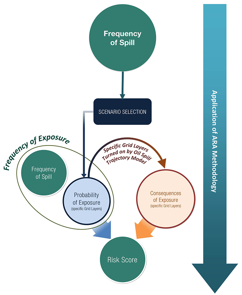
Transport Canada required a method to assess the risk of ship-source oil spills in Canadian waters. While oil spills are unlikely, Transport Canada needed a methodology to assess the risk posed by future projects and potential growth in marine traffic. Dillon led the development of an Area Risk Assessment (ARA) Methodology that determined the probable locations and volumes of ship-source oil spills, where the spills would travel and what would likely be impacted by the oil. The output of the risk assessment was a series of maps illustrating the likely locations and volumes of ship-source oil spills and the most vulnerable areas.
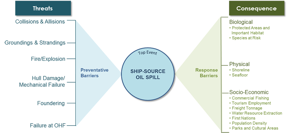
The ARA Methodology was tested by completing assessments in four regions of Canada with high vessel traffic. The methodology is applicable south of the 60th parallel taking into account biological sensitivities (e.g., marine protected areas); the physical environment (e.g., shoreline classification); socio-economic factors (e.g., impacts to commercial fisheries); and Indigenous communities.
The methodology evaluates statistically-defined oil spill volumes from both ship and oil handling facility sources based on the annual frequency of occurrence or return period. Dillon and RoyalHaskoningDHV developed a conceptual risk model using the BowTie method in collaboration with TC, Fisheries and Oceans Canada (DFO), Environment and Climate Change Canada (ECCC), the provinces of British Columbia, Quebec, New Brunswick and Nova Scotia, and the Canadian spill response organizations.
Dillon and MARIN, used a model to predict the location, frequency and volume of oil spills from vessels in four assessment areas. Once the probable locations of ship-source oil spills were known, oil spill fate and trajectory modelling was performed by RPS ASA. The output of the modelling calculated the probability of exposure to oil on the sea surface, shoreline, in the water column and on seabed sediment within the spill footprint.
The fate and trajectory modelling used a stochastic approach which involved modelling the same oil spill hundreds of times while randomly varying winds and currents. The modelling was first run without any spill response and then rerun using a wide variety of spill response measures including innovative measures like in-situ burning and applying dispersants. This was an innovative stochastic approach to model oil spill response, a first of its kind globally, with a goal to see the change in the extent and impact from the spill.
The fate and trajectory model results were used to determine the impacts of a spill. When oil exceeded a defined threshold the appropriate receptor was considered to be impacted by the spill and a consequence value was calculated. Dillon developed a GIS tool that combined the probability of a spill with the oil spill trajectory analysis and the consequence analysis into a single mapping output that identified the most probable locations and impacts from spill.
As part of the project, Dillon and Transport Canada held over 20 public engagement sessions across Canada in each of the four assessment areas so local communities had a voice in the process and understood the preventative measures in place to prevent an oil spill.
A key output of the ARA Methodology is the ability to identify the most likely locations of a spill in an area, before they occur, in order to put in place mitigation measures that could prevent the spill from occurring in the first place. However, in the unlikely event of a spill, the methodology identified significant environmental and socio-economic receptors within the study area and developed response plans which should help minimize the environmental impact of the spill.
The environmental and economic benefits from using the ARA Methodology are significant as oil spill hot-spots can proactively be identified and preventative measures developed to reduce the likelihood of a spill and eliminate the potential impacts on the environment and economy.
Developing and implementing a risk assessment methodology can, at times, be both art and science. In order to be successful, key elements must always be kept in mind throughout the process. The Dillon team and Transport Canada focused on solving a problem that may never happen. Although the ARA Methodology is a risk assessment tool, it is also a planning level tool that allows the Government of Canada and stakeholders to make informed objective decisions on how to implement spill prevention measures and where to locate spill response equipment.
Awards

In 2018, this project was awarded a Showcase Award from the Association of Consulting Engineering Companies – New Brunswick and a Canadian Consulting Engineering Award of Excellence in the Special Projects category.
Project Details
Project Partner: Transport Canada
Business Unit: Contaminated Sites Management
Service Offering: Disaster and Emergency Response